Showing posts with label glaciers. Show all posts

Monday, June 18, 2012

Exploring Massachusetts' Coastline in Spring! OLA


a blue and yellow gingerbread cottage in Oak Bluffs, Martha's Vineyard
nice  Cape Cod welcome!
It should be fall! But we have to be in Nova Scotia in July so we are here at springtime instead. And the long coastline, cute lighthouses, fresh seafood and a multitude of pretty flowers are so refreshing in these parts of Massachusetts we had not yet explored. Bill and I have each been to Boston several times but not Cape Cod, Martha’s Vineyard, and New Bedford! The Gateway to Cape Cod in Rochester, Massachusetts where we were camped made all within our easy reach!

The Bared and Bended Arm of the Sea
Plymouth Rock, marked 1620 when the Pilgrims came
Cape Cod

Heralded as The Bared and Bended Arm in the Sea, Cape Cod was formed as the recessional moraine of a glacier, resulting in a peninsula in the Atlantic Ocean. But in 1914, the Cape Cod Canal was cut through the base, forming what may be loosely termed an island. Unofficially, it is one of the biggest barrier islands in the world, shielding much of Massachusetts, including Boston, from North Atlantic storm waves but also suffering erosion of its cliffs, at the same time.
Mayflower II, the ship that carried the Pilgrims to our shores
the John F. Kennedy Memorial in Hyannis
At its shoulder is Plymouth where the Plymouth Rock and a replica of Mayflower II are well-known tourist attractions. The Monument to our Forefathers, on the other hand, is a hidden gem!  In the middle of the upper arm is Hyannis where the Kennedys maintained a compound, now donated for government research, though still closed to the public. The city also has an elegant JFK Memorial and a simple JFK Museum surrounded by Rose Kennedy’s roses.   Harwich, Chatham, and Brewster counties form its elbow. There, at the Stony Brook Grist Mill, we saw a herring run.
where the herring ran, beside the grist mill at Stony Brook
remnants of the Marconi's site for the US station
in the first transatlantic wireless transmission to the UK
The Cape Cod National Seashore is its lower arm. Near the Salt Pond Visitor Center are Captain Penniman’s House and the oldest windmill in the US. Near its wrist, at Wellfleet, there is only a mile of land between the gulf and the ocean. Marconi chose the site for the first transatlantic wireless transmission because it had an undisturbed line of sight to Cornwall in the UK.  Along the beach is also where I savored my first bowl of New England clam chowder! Finally, Provincetown, where the Pilgrims first landed before proceeding to Plymouth, makes its fist. A Pilgrim’s Monument and four small lighthouses are highlights of the area, beautifully dotted by flowers that thrive even on its sandy soil.
getting some rest from the sun at a seafood place on the beach at the Cod
Martha’s Vineyard
Steamship Authority ferry to Martha's Vineyard
One sunny day we took the one hour drive to Woods Hole at the Cod’s armpit and rode the 45-minute Steamship Authority ferry to the island called Martha’s Vineyard. The captain who discovered it named it after his daughter Martha and the wild grapes he found growing there. With a land area of almost 90 sq. mi., it is the largest island not connected to mainland US by a bridge or tunnel. The year-round population is about 15,000, swelling to over 75,000 in summer. A study found that cost of living on the summer colony is 60% higher than the national average; housing prices are double.
Tabernacle in the middle of the Camp of gingerbread cottages
 Oak Bluffs, Martha's Vineyard
Ricky and Megan with us at Coop de Ville harbor resto
We docked at Oak Bluffs and immediately proceeded to the well-known pretty gingerbread cottages which surround the Camp whose center is the giant Tabernacle. There were all kinds of pastel colors and designs but I favored those that had yellow, of course. A real estate listing showed that one such small cottage is available for upwards of $350,000! At the Harbor’s Coup de Ville restaurant, not only was my second bowl of New England clam chowder waiting for me but also Ricky and Megan, a lively newly-wed couple of three days! We had a blast!
the island of Chappaquiddick with its ferries
found my spot of yellow daisies
at the end of North St. in Edgartown.
Then we took a 15-minute bus to Edgartown to which the small island of Chappaquiddick (where former Sen. Edward Kennedy’s car accidentally went into the water and his young female companion drowned) is connected by a small ferry.  But the best part of this town is walking along North Street which runs parallel to its coast. It is lined on both sides by beautiful homes, one side enjoying the waterfront at their backyards. But all the front yards are adorned by pretty spring flowers and verdant greens. I found my spot at the far end on a field of yellow daisies with a small lighthouse at the background!
a North St., Edgartown home...with yellow flowers!
New Bedford Whaling Museum
New Bedford

New Bedford was once the richest city in the world; it was the center of the great whaling industry and now its Whaling Museum is the largest in the world. Beside it is the the Mariner’s Home next to the Seamen’s Bethel (or church. At its Harbor, the old Schooner Ernestina is still docked as another reminder of the whaling days. There is also a memorial to those who lost their lives at sea and a Fisherman’s Memorial fronts the fishing boats. Downtown there is a Whalers’ Memorial which reads, ‘a dead whale or a stove boat’ beside the statue of Lewis Temple who invented the harpoon tip.  But the affluent times are best memorialized in the large mansions and lush gardens around town.
Downtown Bedrord's Whalers' Memorial
flowers on the sandy shores of Cape Cod
Although I felt that the Outer Banks of North Carolina are still better than Cape Cod, the totality of the coastal communities of Massachusetts…the Bare and Bended Arm, Martha’s Vineyard, and New Bedford…offered more variety for everyone’s notion of beauty. New England is truly lovely…and, I can now say, not just in fall! Sigh…our children are all in the west so that is still where we will probably settle! Maybe, just a gingerbread cottage for summer, Bill?
a lonely biker during low tide at the Cod


For more pictures, please go to my albums on our facebook account named billncarol colborn!  
.                                                                            

Tuesday, June 7, 2011

Going, Going, Gone at Glacier National Park! OLA

Wild Goose Island on St. Mary Lake along the Going-to-the-Sun Road 
When we were at Lake Louise at Banff National Park in 2007, I was shocked at its diminished ice caps from a 2005 trip. At Glacier National Park I felt a deep sadness. In 1850 there were 150 glaciers and in 1910 it was established as a national park. Now there are only 26 and by 2030 they will all be gone!  Glacier National Park will cease to exist, only 120 years after it was born. We may have done our best to rescue wildlife from endangered status but conserving glaciers is beyond human capability or will.

the view from our RV
Erroneously, I thought that Glacier National Park would be ok in June! This year, unfortunately, it has not been true. Our transition from the tropics to temperate weather, from hot and humid to cold and (lows of 39 degrees Fahrenheit made colder by 20-30mph gusts of wind) has been anything but smooth. Everyone laughed when I donned my Burberry trench coat, alpaca wool hat, and felt gloves! Uncharacteristically, I literally forgot about form and went all the way for function.

a great view
Glacier National Park is a wondrous wide wall of glacier-topped mountains, six of them above 10,000 ft., many above 9 and more above 8, spanning 16,000 square miles, straddling both the northern border of Montana and the southern border of Alberta and British Columbia. As we drove around the Going-to the-Sun Road, in itself an engineering wonder at 50 miles of the most scenic mountain highway in the world, I told Bill that I thought that this is like the Tetons…although much grander in scale!

Mama Bear and Baby
along the road to Many Glacier
We saw picas prancing around small meadows, mountain goat herds dotting mountain ridges along the road to Many Glacier, deer cavorting on our campsite, moose and baby drinking from emerald blue lakes, and mama and baby bears feeding on berries along the Going-to-the-Sun Road! One of the most dramatic features of this geological overthrust is visible in the form of Chief Mountain, an isolated peak on the border, 9,008 ft. of solid rectangular rock standing singularly powerful amid the plains of aspens and evergreens. No wonder he is called chief!

Formidable Chief Mountain
As it turned out the 6 days we had planned to get ready for our northwest to southeast trek was not enough! From getting dental and medical checks to RV maintenance routines, on the last day we found out that we had water and heating problems! Unluckily, no slots were available at Camping World. Fortunately, Blue Creek RV near Spokane fixed our water issue. So we headed on out to the Park thinking we could dry camp. Boy, were we wrong.  Unsuccessful in trying to keep warm during with double blankets each, we transferred the following day to the KOA campground just a mile off the park.

the Vidallos and Colborns
My daughter Claudine, husband Arnold, and kids Ashton, Andre, and Enzo (my very first grandson!), drove from Calgary, Alberta for 3-4 hours to meet us there. For us it was a 6-7 hour drive from Spokane. Amazingly, we arrived at campsite 316 only 5 minutes apart!  Then the fun with the family began. From driving slowly to scope animals, to fixing smokes over a campfire, to getting mercilessly beaten by my daughter Claudine at Scrabble and Upwords (did I teach them well!), and the kids getting their Junior Ranger badges at the St. Mary Visitor’s Center at the East Entrance, the experience was way too cool!

Ashton, Andre, and Enzo
being sworn in as Junior Park Rangers
red shuttle bus
Our memories are even made better with the expertise in photography that Arnold brought with him. Although we are using photos from our camera on this post, Bill and I learned a lot of new tricks from him.  (Please visit his website @ http://3klixphotography.smugmug.com). Actually, we are now considering a wide-angle lens with longer zoom! 


mountain goats dot the mountain ridges
If only we came during the heart of the peak season (July-August), then probably our visit to Glacier National Park would have been perfect. However, knowing that 19 years from today all the glaciers would be gone, we are glad that we found time for it this year! After all, it is the first International Peace Preserve Park, shared between Canada and the US (the Vidallos are Canadians, we are Americans!) Enzo said it best, ‘I don’t wanna go home‘.  But, just like the Park, they were going, going, gone. Sigh!

Next Stop:  Converging at Yellowstone!

Tuesday, December 7, 2010

Staying Awhile in the Evergreen State-Blaine

M'A'turn @ Beachwood RV Resort
Our stay in Ponderosa Falls in Spokane was so nice we thought nothing could top it…that is, until we reached Beachwood RV Resort, another K/M campground (K/M stands for Kevin and Mike, co-owners of around 7 sites in Washington). Our stay there was memorable for a nice string of visits, parties, and recreation. So the three weeks we were there I have named our Sing, Eat, and Dance weeks.


Birch Bay State Park
 The Resort has two large pools (one heated and enclosed with a bubble during cold weather), three hot tubs (one of which is indoor), a dry sauna, an adult lounge with billiard, pingpong and other tables and a youth lounge with billiard, pingpong and fusbol tables, a nursery area, and a video arcade. Outside are tennis courts, driving range, and a playground. And the general store is a good-sized grocery.


me on a beachwood at Birch Bay
   A nice 10-minute walk through the beautiful (especially the change of colors in Fall) Birch Bay State Park behind the store leads you to Birch Bay, with lots of big, artsy driftwoods adorning the beach (hence the name). At the bay are various recreational activities with kayak, bike, and golf rentals, and a large mini-golf course. Famous for sinful, tasty fish and chips, Birch Bay is a touristy community of vacation homes.


the Aberions in front of the cabin
  The first week, Deejay’s family (Tavy, his dad, Darlyn, sister, and husband Paolo) and Trisha and the two kids Yeye and Kenji were in a cottage beside our RV. I call the first week Sing because Tavy is an avid karaoke singer and so we had a great time singing at night after the morning sightseeing trips and afternoon recreational activities as the resort. An avid karaoke ‘performer’ myself, I had loads of fun!


the spit that splits
The second week I call the Eat week. Our friends Benjie and Fides Alviar came to visit us again. On the first day we toured them around Birch Bay and could not help but feast on the famous fish and chips! Then we went to Semiahmoo (meaning half moon) Bay. Beachwood is in the city of Blaine whose harbor is separated from the main body of the bay by a Spit, on which is the Semiahmoo Resort. The spit splits the bay such that it looks like a half moon. From there one can see White Rock, a city in Canada.
a view of White Rock from the parkway that leads to the Resort
Blaine’s northern boundary is the Canadian border. The city is home to the two main West Coast ports of entry between the United States and Canada, the Peace Arch Crossing, the primary passenger vehicle port of entry, and the Pacific Border Crossing, about a mile east, the primary point of entry for heavy truck traffic, and thus is known as the Truck Crossing.
admiring the kiosk of the concrete factory


trying to unsettle the pigeons

So the next day we went to Vancouver, BC, only about an hour away where we again could not help but sample exotic fruits and other goodies at Granville Island where my most favorite public market in the world is located. At the boardwalk are dozens of pigeons waiting to be fed. In the middle of one-of-a-kind shops a man dressed in a ballerina outfit was entertaining crowds. We even found a concrete factory that told its story in an interesting kiosk’ near its entry.


the ballerina on Granville Island


with Bolet, in front of Pinpin
   Then we went to meet another friend, Bolet, who lives in Vancouver, at the famous Pinpin restaurant where hordes of Pinoys and Pinays (what we fondly call people from the Philippines) eat because of its many authentic Filipino dishes. And, though we had a lunch that our tummies could not carry, we still went to the Newtown Bakery in Chinatown to buy our siopaos and other Pinoy treats. 


playing billiards???

On the last weekend our guests were Krishna, my eldest grandchild, Randy, her boyfriend, and Diana, his sister. However, the teens were not interested in sites! Instead they frequented the hot tubs and lounges. On Saturday night we all went to the crab feed where I finished two whole crabs and two pieces of roast chicken! But I call this last week our Dance week because after the Feed there was live band music. Bill and I danced the night away with another couple from Canada, members of the resort.

Mt. Baker in all its glory

a sighting of an American bald eagle
 In between these weekend visits were trips to Bellingham, Mt. Baker, and the towns of Concrete (yes, they make concrete there) and La Conner (in the heart of Skagit Valley, the tulip country in America and, although the flowers are not in season until spring, that is where I saw my first bald eagle by the road), Washington.  Bellingham is the largest city in, and the county seat of, Whatcom County. Situated on Bellingham Bay. 

a nice spot on a city ridge overlooking Bellingham Bay
a strikingsculpture on WWU campus
Although Bellingham is smaller than neighboring metropolitan areas such as Seattle, Vancouver, or Victoria, the city and its surrounding region offer many attractions which are popular for both residents and visitors. The city’s scenic splendor is appreciated by residents and tourists, mainly from Canada. Cliffside views of the San Juan Islands and the glaciers of Mt. Baker can be seen from the city. Even Western Washington University is a tourist destination for the countless sculptures around the campus.

the entry to Concrete, Washington
Certainly those three weeks of Sing, Eat, and Dance make it into our book. We were in Beachwood the latter part of October and early November. What more could we have enjoyed if we were there during spring or summer??? But the holiday season (Thanksgiving, Christmas, and New Year) is about to begin so we went on to Monroe, Washington to be closer to family and friends!
the Cascades with an urban foreground


Tuesday, September 14, 2010

Flying to Alaska for a Wedding, Part 2

Last year we were able to go to Tok, Valdez, Palmer, Anchorage, Whittier, Homer, Wasilla, Denali, Fairbanks, North Pole, and Chicken, Alaska. This year, when Cris and Mitch went off for their honeymoon, we took the opportunity to go to Soldotna/Kenai, Seward, and Mt. McKinley.

Soldotna and Kenai are on the mouth of the famous Kenai River on the Kenai Peninsula, just slightly off the same road we took to Homer last year.  So we got to revisit the usual spectacular scenes of glaciated mountains glistening above the waters. Together with Homer and Cooper’s Landing (where we stopped for the best smoked salmon chowder I ever tasted), they are well-known fishing towns. But this year, the summer is colder, wetter, and darker. It was so windy I became paranoid that my brand new alpaca winter hat would be blown away. 

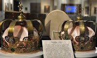
Even the snow-capped mountains seemed farther away and hidden by haze that the pictures were not as bright.  The saving grace was the quaint little Russian Orthodox Church in the Old Town of Kenai, built at the turn of the nineteenth century. We even found a set of wedding crowns we could wear! Bill also felt so good to find that, in Soldotna, an organization is doing better than Walmart at catering to the needs of the RV industry enthusiasts!  Fred Meyer, besides being a place to dry camp for the night, had complimentary dump and potable water stations!

Bill was very sensitive to my frustration that, instead of going back to Anchorage the next morning, he headed off to the other side of the peninsula, to the town of Seward, at the mouth of the Kenai Fjords National Park. I felt that Whittier (from where we took the Glacier Bay cruise last year) is prettier (it rhymes!) though smaller. It was already off-season so there was hardly any soul on the waterfront.  But the boats are all still moored on the marina and the shops were still open. A long pipe coming down from a strange huge equipment on the bay was still a mystery to us as we left.

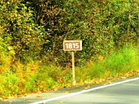
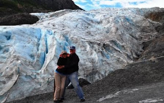
 8 ½ miles west of the town lies the famous Exit Glacier (part of the huge Harding Ice Fields of 500 square miles), so named because it has been receding slowly since the earliest recorded terminus in 1815 (the recordings are so marked along the way), about 2 miles from the current one.  One can imagine the size of the glacier from the marshland it is creating at its foot. I welcomed the chance to finally walk on the glacial ridge just as Bill did at the Worthington Glacier in Valdez last year.  But it was so cold, like I was inside the freezer.  Quickly, I turned back after the photo op. 

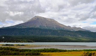
Then the soggy weather changed and we got the chance to go for a view of Mt. McKinley which, at over 20,000 feet, is the highest peak in North America.  It is useful to point out that, although there are 650 higher peaks in the Himalayas and 44 in South America, you look at McKinley rising from a base of sea level and thus looks so ‘gi-normous’, as Bill’s granddaughter Cassie would say! Last year, the mountain was totally covered with clouds even as we took the Denali National Park bus to the best viewpoint inside. 
They say only 30% of those who go to see it, get to.  I am so proud to say that, this year, we finally did! 

It was an increasing spectacle as it loomed larger and larger from Anchorage to Talkeetna, a drive of about 134 miles.  There are three great viewing points: Denali South (Mile 135) and Talkeetna hill in the south and Denali North (Mile 163) and Wonder Lake (inside Denali National Park) in the north.  The headline photo is from Denali South and the photo here is from the Mt. McKinley View Lodge half a mile before Denali South which we accidentally found as we looked for food when I got hungry! 

One last note   The US Open was on while we were in Anchorage and I got to see enough of it except for those times we were out sightseeing which we, of course, timed during those matches when Nadal , my favorite, was not playing.  The men’s final was supposed to be on the day we left, at 12 noon (our flight was at 5:30 PM).  So with our bags packed and safe in the Cristine’s car, we holed up in the TGIF Sports Bar! Unluckily, the match was postponed to the following day because of rain. But we got to watch it in Monroe and Nadal is now the US Open Champ!

Next Stop: Monroe, Washington