Showing posts with label Star and Vino. Show all posts

Tuesday, November 22, 2011

WOW: Classifying Campgrounds

Star and Vino at the Joshua Tree National Park, a nature preserve
RV camping is very much alive in the US. Out of 30 million RVers in almost 9 million households, about 1.3 million are full timers like Bill and me. We all have almost 2,000 campgrounds to choose from. Cost, location, and facilities may be hard to balance. Being members of Thousand Trails, we can stay at any of their campgrounds for three weeks at a time so it is not that hard. But those three weeks should be as enjoyable as possible so there is still a choice to make. I came up with the following system.

3 quadrants: RV Park, country club, RV haven, and nature preserve
 Construct a chart with an x-axis and a y-axis. Let the x-axis stand for the location of the campground from city to country, going from left to right, and let the y-axis represent amenities and activities from basic to special, going from up to down. We can thus subdivide the space into four quadrants. Going counter-clockwise, at the upper left quadrant is the RV Park, lower left quadrant is the Country Club, lower right quadrant is the RV Haven and upper right quadrant is the Nature Preserve.

camping at the Docks' driveway
RV Park
This is an RV campground within or almost within city limits and has basic amenities or activities, often none. An example is The Oaks at Point South which became our jump-off point to Beaufort, Hilton Head, and Savannah for my friend Dittas when she visited us. But the best example of this category is a hotel in Hermosillo, Mexico which allowed RVs to park at their back parking lot. Another great example is the campground which was within walking distance of the French Quarter in New Orleans!

Walmart RV Park
Now Walmart is America’s best known RV Park! It is said that the average “campsite fee” is $45, the amount one spends for one night of stay. So other grocery chains have followed this excellent strategy. Canadian Tire even has dump stations and fresh water. Belonging to the same class are rest areas (a great number is being shut down due to lack of funds), huge truck stops, and even casinos. But the best example is the driveway of the Rosemary (Bill’s sister) and her husband Jack’s home in Pittsburg,

Country Club 
Palm Springs Country Club
Close to a city, this campground also has many amenities and activities! Where we will be next week, Orlando Thousand Trails in Orlando, Florida is of this type. So is Las Vegas Thousand Trails in Las Vegas, Nevada. They are both just a few miles from great tourist spot and have all the musts: amenities like pool and hot tub, fitness center, mini golf, table tennis and billiards, tennis and other outdoor courts and activities like karaoke, dancing, Texas hold ‘em, pot lucks, movie nights with free popcorn, and concerts.

Nature Preserve 
dry camping at the roadside enroute to the Arctic Circle
Far from a city, this campground may not have amenities or activities but there are fantastic views afforded by its special location. A good example is Kirk Creek Campground of the US Forest Service right at the cliff overlooking the Pacific Ocean in Big Sur! State Parks are the same. The campgrounds within well-known national parks of the National Park Service like Yosemite, Yellowstone, Grand Tetons, Great Smoky Mountains, the Grand Canyon are perennial favorites but require months in advance to book.
Bill relaxing at our campsite in Green Mountain, an RV haven

RV Haven 

Farther from the city, this type of campground is also well equipped with amenities and activities. At Green Mountain Resort in Lenoir, North Carolina, each campsite has a large deck beside a little stream which makes soothing ‘music’ throughout the day. The park also has a lake for fishing and great hiking trails all around, a tennis court, a 9-hole golf course, a large clubhouse with pool and table tennis tables, and eature great concerts and parties. Because it is near the town of Lenoir, we could also use the community center’s gym and spa.

a nature haven in winter...
The statistics of RVers is up by almost 10 percent from 5 years ago! And although the 2,000 campgrounds may not all be full all year-round (northern ones are busy during summer while southern ones are cramped during winter), given the right time of year, they can be literally buzzing with activity. To maximize enjoyment, we need to choose the campground well. After all, it is our home for the duration of our stay. So I have found this classification system very helpful.

a country club in fall
We like country clubs and RV havens best. But we also take short breaks in nature preserves. M’A can comfortably dry camp only for 4 days max (constraints of fresh, black, and grey water tanks and battery power). On the other hand, RV parks are places we use to rest for a night (or as a jump-off point) as we make our way to our next campground. We usually try to limit RV driving to at most 6 hours a day. Driving longer can become pretty tiring for Bill (and really boring for me)!

We looooove the campground infrastructure in the US but we often wonder how it is in Europe or Australia/New Zealand? Can we RV there as well? Watch for the results of our research!

Tuesday, July 12, 2011

WOW: Becoming More Than Tourists

colorful murals on old grain elevators off I-80 in Omaha, Nebraska 
We started this cruising lifestyle right after Bill sold his business in February 2009. We went to the Philippines for a 2-month visit, after which we visited Bill's friend in Taiwan for 2 weeks and flirted briefly with the idea of teaching English there! But as soon as we were back in Seattle, we sold most of our belongings in about 3 garage sales and several listings on craigslist and bought Star, our very first RV. Then we had our condo rented out, off we went to become full time tourist!

We have completed these trips: from Seattle to the Arctic Circle and back to Seattle-July to September 2009,  from Seattle through Mexico to Florida-September 2009 to March 2010, and from Florida back to Seattle-April 2010 to February 2011.  On this last trip, we bought our current RV/dinghy, M’A ‘turn. Then we visited the Philippines and HK for 3 months and now we are on the 2nd month of our 4th trip, from Seattle back to Florida (June 2011 to March 2012)...about 50,000 miles among Star, Vino, & M'A'turn!

Our 5th trip will be from Florida to Nova Scotia to Nevada (April to November 2012) , after which we may return to Asia or begin our European tour! You may see the two maps on our left side bar to see our progress! We started out as tourists, armed with a bucket list of 50 states and 88 countries. Thus far we have visited 27 and 5, respectively…certainly a long way yet to go. But now our 2 boards are heavy with  our collection of magnets and are we glad we bought our Nikon SLR!

A tourist is defined as a person who is traveling for pleasure. We have certainly fitted that description! Just look at our last 3 posts which cover the Great Plains. Driving through the I-80 leaving Omaha and going to Council Bluffs, Iowa, we spotted these huge old grain elevators painted with murals! Then, while our RV’s heating/air-conditioning system was being repaired at Camping World, were told there is a unique rotary jail that served as the county jail from 1882-1969!  Yes, that’s right…rotary!
the model of the rotary jail

The jail has 3 floors and looks like…a large bird cage, actually! It is cranked by hand to let any cell open to a fixed door on each floor which has 10 cells. Designed for 2, sometimes 5 were made to fit each one! The ground floor of the shell had tables for free time.  Efficiency, not only in space but in guards (needed only 2), and security were the reasons for the design. It was discontinued when it suffered a slight tilt and people realized that it could be a fire/death trap.

Carol with an inmate
From this place of inhumane conditions, we next found the Grotto of Redemption. The problem was it is about 70 miles from I-35, our route to Minnesota! That meant about a 3 hour diversion and about $65 in gas. But the little ad on the Iowa travel mag said it is considered to be the Eighth Wonder of the World, much like what Filipinos say of the Ifugao Rice Terraces in the Philippines! So we unhooked our ‘turn, left our M’A at a church parking lot in Clear Lake, Iowa and proceeded to West Bend.

frontal view of the Grotto 
Indeed, the Grotto is a very special place. It is a complex of 9 grottos (Garden of Eden, 3 grottos of the Stations of the Cross, Stable of Bethlehem, Jesus'  home in Nazareth, the Trinity, Ten Commandments, and Gethsemane), made from 43 different kinds of gems. The most delicate stones are in the Grotto inside the Christmas Chapel. They were made entirely by the hands of 3 men. Father Dobberstein, who studied geology in Germany before migrating to America and entering the priesthood, offered to build this shrine to the Blessed Virgin for her intercession when he was with pneumonia.

back view of the Grotto
He became a pastor in West Bend in 1898 and started collecting rocks and gems from all over the US with the help of his right hand, Matthew Szerensce. Work on the Grotto officially started in 1912 and upon his death in 1954, about 80 % of the plan was done. 8 years before his death, Rev. L.H. Greving started to assist him in the parish. Together with Matthew, he continued his work after the death of Father Dobberstein until his own passing in 2002.

Grotto of Incarnation
at the Christmas Chapel
Now the Grotto is estimated to be worth over $2M in materials, priceless in labor!  That was, I thought, a true, though little, pilgrimage! A pilgrim is a person who travels, especially over some distance, to a sacred place as an act of devotion. There was a smile of my face…we are probably becoming more than tourists! And that song I have come to love so much, America the Beautiful, took on greater significance. ‘O beautiful for spacious skies…..O beautiful, for pilgrim feet!

The better known first stanza is for America’s natural beauty which we have certainly visited as tourists. But the second is for America’s human beauty which we are also discovering as pilgrims! After all, Bill and his forefathers were pilgrims and I may have just become one! When we visit Wisconsin, we plan to make another little pilgrimage to Holy Hill, suggested to us by our friend, Didi Manarang, Deputy Commissioner of the Bureau of Customs in the Philippines. And we will embark on more!

Wednesday, November 17, 2010

Exploring the Southwest

From the bustling metropolis of Los Angeles, we reached the city of Palm Springs where ''snowbirders' were already congregating for the winter. Located in the Coachella Valley desert region, it is sheltered by the San Bernardinos to the north, the Santa Rosas to the south, the San Jacintos to the west and the Little San Bernardinos to the east. This unique geography gives the city its hot, dry climate, with 354 days of sunshine and only 5.23 inches of annual rainfall. The coolest days in winter are in the lower 70s °F and the nights fall to the lower 40s °F. No wonder.

The City of Palm Springs' best-known mayor was Sonny Bono and though celebrities still make it a place of regular retreat, many others like Palm Desert and Rancho Mirage have also become as popular. Bill and I were treated to our first deluxe campground with hot tubs, pools, recreation rooms and lots of activities. Towering date palm trees dwarfed our little Star. On a Saturday potluck dinner and disco night, we found our first buddies on the road. So we decided to buy into this lifestyle and bought into the Thousand Trails+ system with over 300 in North America!

This is a place to come back to...in fact, maybe even settle in later!. The world's largest rotating aerial tramcars in the Aerial Tramway, climbs to more than 8,000 feet, with a 30 degree decline in temperature, a 360 degree view of the valley, and a top-notch restaurant at the top, a most welcome treat in summer! The Palm Springs Follies stage-show features performers that are over the age of 55 (I knew can still be a star!). Every Thursday evening downtown is transformed into a Village Fest on famous Palm Canyon Drive. Vino 'scootered' us through streets named after Frank Sinatra, Bob Hope, and the like!

And only a few miles east is Joshua Tree National Park, named for the Joshua tree forests native to the area. Covering a land area of 789,745 acres the park is, in fact, two deserts, each a separate ecosystem supporting diverse life, both vastly different from life we know!. The higher, drier, and slightly cooler Mojave Desert is home to the Joshua tree (the biggest one we found stood at 50 ft!) and hills of bare rock, formed a million years ago, of quartz monzonite, a very rough type of granite (because there is no snow or ice to polish it like in Yosemite), are very popular with rock climbers. 
 
Below 3,000 feet, the Colorado Desert features habitats of such dense cactus that form natural gardens. The California Fan Palm, only native to the state, occurs naturally in five spectacular oases in the park, areas where water occurs naturally year round, supporting many forms of wildlife. The southern lookout point at Keys View offers breathtaking views of the Coachella Valley and Salton Sea. We dry-camped at one of the nine park campgrounds. Unlike Palm Springs though, this is definitely not one that we will consider to settle in, but it was exhilarating at dusk and specially at dawn.

South of the park is the Salton Sea, a saline rift lake located directly on the San Andreas Fault. Like Death Valley, it is below sea level, at 226 ft. The sea is fed by three rivers, as well as toxic pesticide laced agricultural runoff drainage systems and creeks from nearby farms..Covering about 376 sqmi, it is the largest in California. But it should really be called the Dying Sea. It was certainly sad to see multitudes of dead fish on the expanse of beaches. In just two weeks, we had moved from a city of upscale living, to lonely desert life, to a sea of death. 
 
The Salton Sea was created in 1905, when heavy rainfall and snowmelt caused the Colorado River to swell. The resulting flood poured down the canals and breached a dike. Over a period of two years two newly created rivers sporadically carried the entire volume of the Colorado River into the Salton Sink. This basin was formed for 3 million years as the Colorado River built its delta in southwestern US, creating a massive dam, excluding the area. Depending on the balance between inflow and evaporative loss, the Sink has long been alternately a fresh water lake and a dry desert basin, 
 
The Southern Pacific Railroad attempted to stop the flooding but the effort was not fast enough and a massive waterfall was created. It rose to a height of 80 feet before the breach was finally stopped. As the basin filled, the town of Salton, a Railroad siding and some Indian land were submerged. The sudden influx of water and the lack of drainage resulted in the Salton Sea of today. But by the 1925s, the Salton Sea developed into a tourist attraction, because of its water recreation and the waterfowl that flock to the area.

Called a "crown jewel of avian biodiversity”, over 400 species have been documented. The Sea even supports 30% of the remaining population of the American white pelican and is a major resting stop on the Pacific Flyway. With relatively high inflow salinity and lack of an outlet, the Sea's salinity has increased by approximately 1% per year. Currently, at 44 parts per 1000, it is saltier than the Pacific! Many species of fish are no longer able to reproduce or survive in the Sea as the runoffs have resulted in elevated bacterial levels and large algal blooms, major food sources for migrating and wading birds!

The Salton Sea is definitely not a place for us to settle in but we thought, 'It was good to be able to see the miracle that, unfortunately, will probably not last.'. This segment of our cruising lifestyle was truly learning about different conditions that support life!' And that is what traveling is all about!

Next Stops: Julian, Ramona, and San Diego, California plus Casa Grande, St. David, and Arizona

Tuesday, November 9, 2010

Driving Down the West Coast: Solvang, Santa Barbara, Malibu, and LA

Once the euphoria of Big Sur and the colony of elephant seals subsided, we drove along the looooong California coast to savor its famous beaches! First, the magical town of Solvang, then upscale Santa Barbara, on to sunny Malibu, and then, finally, we turned into cosmopolitan Los Angeles.

One of our friends told us not to miss Solvang, the little Dutch America. So we went and found just what she described...a town with windmills on top of buildings, the museum dedicated to Hans Christian Andersen, lots of specialty outlets such as the Olive House, and little wine shops with joyful staff, great free food, and good jazz.

Situated on an east-west trending section of coastline, the longest such section on the US West Coast is Santa Barbara, lying between the steeply-rising Sta. Ynez Mountains and the Pacific Ocean. Santa Barbara's climate is often described as mediterranean, and the city is sometimes referred to as the "American Riviera."

Our campground, however, a little way off the coastal city into the wilderness areas of Los Padres, beyond Santa Ynez. Huge oak trees that dwarfed our Star and three other RVs were the only ones in the vast acreage! When we went into town, we took Star because I could not ride Vino for longer than 15 minutes. So, we had to pay double parking fees!

I thought the shopping on State Street, the trendy main street of the city, can beat Rodeo Drive. And the Mission at Santa Barbara was truly one of the first (founded 1716). The wharf also looked so coooool! The following day we transferred to a state park along the coast just past the city and nestled quietly into the night with a beautiful California sunset to begin it.

And, soon after our start the following day, came 17 miles of scenic coastal drive on famous Malibu Beach. The beach homes are huge, some dramatically hanging off cliffs and some artistically jutting over the water. Then there was Malibu Pier, the historic landmark adjacent to Surfrider Beach, known for its three-point break that offers rides of 300 yards or more. And, even in that chilly October afternoon, the surfers were there!

Finally, we reached Los Angeles with its coral trees lining its boulevards. And how could we miss Rodeo Drive, Beverly Hills, the Scientology Center, the Kodak Theater, and the Grauman's Chinese Theater which opened in May 1927 with its red carpet and cement walk filled with signatures and palm prints of stars like Olivia de Havilland and Donald Duck?

Bill got to have his photo taken with Marilyn Monroe while I felt like I was another star on the Walk of Fame, a series of sidewalks on about 15 block segments of Hollywood Blvd. and 3 on Vine St., a permanent monument to great achievements in the entertainment industry. More than 2,400 stars are embedded at 6-foot intervals over a combined 1.7 miles.
Later, we dropped by Universal Studios and then took our own photo version of the Hollywood sign on the Hill! Despite all our excitement, the city did not make it to our select list of where we will settle after our RV cruising lifestyle is over. We couldn't afford it! So, we proceeded to our next stops: San Diego, Julian, and Ramona in southern California.


Tuesday, November 2, 2010

Driving Down the West Coast: Big Sur and San Simeon

Big Sur is the sparsely populated region through which Highway 1 runs on California’s coastline that has the Sta. Lucia Mountains rising sharply out of the Pacific Ocean! As we left Monterrey Bay, Carmel, and Pebble Beach, one stunning scene after another held our breath. It was even more incredible that we found a campground (we had no reservation) of the National Forest Service right there between the mountains and the deep blue sea! The section of Highway 1 running through Big Sur is widely considered as one of the most scenic driving routes in the United States, if not the world.

Big Sur's Cone Peak is the highest coastal mountain in the contiguous 48 states, ascending nearly a mile above sea level, only three miles from the ocean. The northern end of Big Sur is about 120 miles south of San Francisco and the southern end is approximately 245 miles northwest of Los Angeles. Only about 1000 inhabitants, descendants of the original settler and rancher families, artists and other creative types, along with wealthy home-owners from the worlds of entertainment and commerce live there.

There are small clusters of gas stations, restaurants, and motels which are called "towns": Big Sur, in the Big Sur River valley, Lucia, near Limekiln State park, and Gorda, on the southern coast. The economy is almost completely based on tourism. Much of the land along the coast is privately owned or has been donated to the state park system. The mountainous terrain, environmentally conscious residents, and lack of property for development have kept Big Sur unspoiled, retaining an isolated frontier mystique.

The land use restrictions that preserve Big Sur's natural beauty also mean that tourist accommodations are limited, often expensive, and fill up quickly during the busy summer season. There are fewer than 300 hotel rooms on the entire 90 mile stretch between San Simeon and Carmel, only three gas stations, and no chain hotels, supermarkets, or fast-food outlets. The lodging options are rustic cabins, motels, and campgrounds, or costly, exclusive five-star resorts, with little in between. We found the 
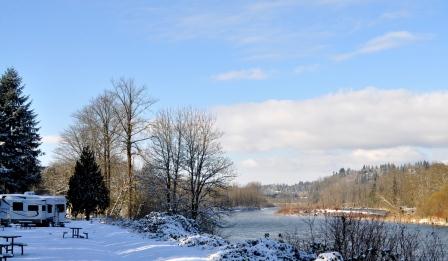
Kirk Creek Campground of the National Forest Service for only $10 a night (Bill holds a Golden Passport)!

It was the perfect place! We hiked to a small beach below through some trails along the ridge. The beaches of Big Sur are unsuitable for swimming, however, because of unpredictable currents and frigid temperatures. Other notable points are The Bixby Creek Bridge and nine state parks, one of which has one of the few waterfalls on the Pacific Coast that plunges directly into the ocean (although visitors are not allowed on the beach itself to preserve the natural habitat). And a photo of Bill on a chair carved out of a tree perched on a ridge is a priceless treasure!


Most of the 3 million tourists each year never leave Highway 1, because the mountain range is one of the largest roadless areas near a coast in the contiguous United States. The highway winds along the western flank of the mountains mostly within sight of the Pacific Ocean, varying from near sea level up to a thousand-foot sheer drop to the water and as such, gazing at the views while driving is inadvisable. During a looooong stretch, I nervously held on to my seat as the RV (Star) is much higher than a car. Every five minutes or so I pleaded with Bill to slow down as he drove at 10 mph!

When we reached the end I heaved a big sigh of relief!!!!! But I never expected the big reward waiting for us at the town of San Simeon…thousands of mostly immovable huge animals lying on the beach! It is the largest elephant seal rookery on the West Coast, located just south of the 105-foot 10½-inch Piedras Blancas Lighthouse. Elephant seals are large oceangoing seals. Its two species were both hunted to the brink of extinction by the end of the nineteenth century, but numbers have since recovered and the northern species have chosen the Pacific coast of the US, Canada, and Mexico for mating.


Elephant seals take their name from the large proboscis of the adult males which resembles an elephant’s trunk. They produce extraordinarily loud roaring noises during the mating season. They also act as ‘rebreathers’ since they are filled with cavities designed to reabsorb moisture from the animals' exhalations. This is necessary when the male seals rarely leave the beach to feed and therefore must conserve body moisture during mating season. Bulls reach a length of 16 ft. and a weight of 6,000 lb.


What a reward! Next: Santa Barbara and Los Angeles!